Fichier:Wsr74c Huntsville AL.jpg
Aller à la navigation
Aller à la recherche

Pas de plus haute résolution disponible.
Wsr74c_Huntsville_AL.jpg (562 × 512 pixels, taille du fichier : 56 kio, type MIME : image/jpeg)
Description
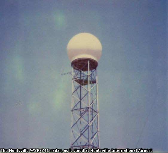
| Description |
Français : Radar WSR-74C du National Weather Service à l'aéroport international de Huntsville, Alabama. Ce radar fut remplacé par un WSR-88D en 1997 situé à Hytop, Alabama. Il est maintenant utilisé par l'université de l'Alabama pour la recherche
English: WSR-74C radar at the Hunstville International Airport when the NWS office as there. It was replaced by a WSR-88d (NEXRAD) in 1997 at Hyptop, AL. It is now used for research by the University of Alabama in Huntsville. |
| Date | années 1980 |
| Source | https://www.weather.gov/images/hun/stationhistory/wsr74c.jpg in the NWS Huntsville History page |
| Auteur | National Weather Service, Huntsville, AL |
| Lieu de la prise de vue | | Voir cet endroit et d’autres images sur : OpenStreetMap |
|---|
Conditions d’utilisation
| This file is in the public domain in the United States because it was solely created by the National Weather Service (NWS), including its name from 1870–1970, the United States Weather Bureau (USWB).
This includes the sub-branches of the National Weather Service:
As a file created by an employee of the NWS (formerly USWB) in the course of their official duties, whether hosted
this work is in the public domain in the United States because it is a work prepared by an officer or employee of the United States Government as part of that person’s official duties under the terms of Title 17, Chapter 1, Section 105 of the US Code. |
||
 |
Warnings: (Click here to view)
|
Historique du fichier
Cliquer sur une date et heure pour voir le fichier tel qu'il était à ce moment-là.
| Date et heure | Vignette | Dimensions | Utilisateur | Commentaire | |
|---|---|---|---|---|---|
| actuel | 13 avril 2012 à 00:24 | | 562 × 512 (56 kio) | wikimediacommons>Pierre cb |
Utilisation du fichier
La page suivante utilise ce fichier :