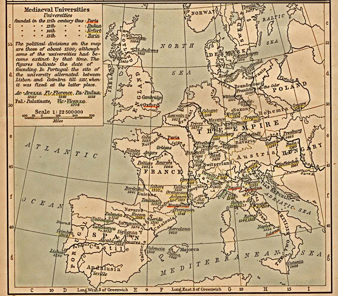
Fichier:Mediaeval universities.jpg
Aller à la navigation
Aller à la recherche
Taille de cet aperçu : 685 × 599 pixels. Autres résolutions : 274 × 240 pixels | 549 × 480 pixels | 878 × 768 pixels | 1 127 × 986 pixels.
Fichier d’origine (1 127 × 986 pixels, taille du fichier : 1,17 Mio, type MIME : image/jpeg)
Description
| Description |
English: Scan from "Historical Atlas" by William R. Shepherd, New York, Henry Holt and Company, 1923. |
|||||||||||||||||||||||
| Date | (the same map was included on a half-page in the 1911 edition) | |||||||||||||||||||||||
| Source | ||||||||||||||||||||||||
| Auteur |
|
|||||||||||||||||||||||
| Autorisation (Réutilisation de ce fichier) |
From the FAQ @ http://www.lib.utexas.edu/maps/faq.html
|
|||||||||||||||||||||||
| Autres versions | العربيَّة | |||||||||||||||||||||||
.png)
Conditions d’utilisation
Cette œuvre est dans le domaine public aux États-Unis car elle a été publiée avant le 1er janvier 1931.
Les œuvres dans le domaine public doivent être inéligibles pour le droit d'auteur à la fois aux États-Unis et dans leur pays d'origine pour pouvoir être hébergées sur Commons. Si l'œuvre ne provient pas des États-Unis, le fichier doit comporter un bandeau de licence supplémentaire indiquant la situation vis-à-vis du droit d'auteur dans le pays d'origine.
|
Journal des téléversements d’origine
Transféré de en.wikipedia à Commons par SreeBot.
La page de description originale était ici. Tous les noms d'utilisateur qui suivent se rapportent à en.wikipedia.
Upload date | User | Bytes | Dimensions | Comment
- 2006-12-18 21:40 (UTC) | Jengod | 361656 (bytes) | 1127×986 | {{PD}} Scan from "Historical Atlas" by William R. Shepherd, New York, Henry Holt and Company, 1923. Original image at the [http://www.lib.utexas.edu/maps/ Perry-Castañeda Library Map Collection] at the [[University of Texas at Austin]] website: http:/
Historique du fichier
Cliquer sur une date et heure pour voir le fichier tel qu'il était à ce moment-là.
| Date et heure | Vignette | Dimensions | Utilisateur | Commentaire | |
|---|---|---|---|---|---|
| actuel | 30 juillet 2012 à 18:31 | | 1 127 × 986 (1,17 Mio) | wikimediacommons>SteveMcCluskey | Improved legibility by reducing extraneous background detail, increasing contrast of image, and enhancing color saturation of underlining. |
Utilisation du fichier
La page suivante utilise ce fichier :